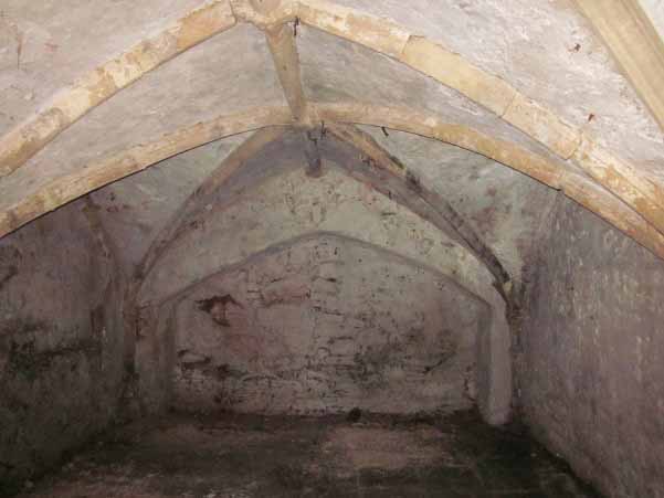
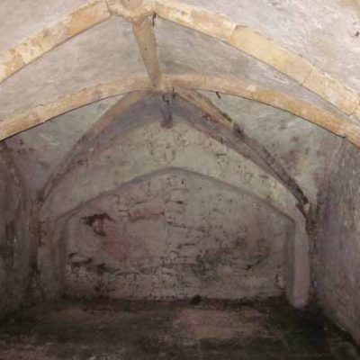
We started at the curious obelisk on High Street, which marks the entry to a complex of decorated cellars of 15th century date. These were on the site of the George by 1532 and are remarkably well-preserved. Unfortunately, public access is not currently possible. They were used for the storage and selling of wine and it is to be hoped that once the site is redeveloped, the cellars will be accessible once more.
We then went down Bridge Street, constructed in 1760 to replace the medieval Shambles, or Worship Street. The buildings were of 4-5 storeys with basements constructed under Bridge Street. We arrived at St Peter’s Church, now a ruin after bombing in WWII, but thought to be Bristol’s oldest church, first recorded in 1107, but certainly much older than this. Bob explained the various theories surrounding the role and foundation of the church and its location at the mid-point of the headland, but possibly just outside the earliest defences. We stood on the former line of Dolphin Street (formerly Defence Street in 1391) where Philip Rahtz found a double ditch, possibly the line of an early eastern defence. At the junction of Peter Street (north of St Peter’s Church) and Dolphin Street stood St Peter’s Pump. The earliest reference to this is of 1391 and a cross was added in the mid-15th century. It was taken down in 1766 and removed to Stourhead where it can still be seen.
We followed the route of the former line of Mary-le-Port Street, one of the oldest streets in the city, partially excavated by Philip Rahtz and found to be of pre-Conquest date. Unfortunately, it now stops at a dead end instead of linking with High Street. We looked at the site of St Mary-le-Port Church, excavated by Rahtz who proved it to be pre-Conquest. It was bombed in the war leaving only the tower intact. It is now in a sorry state, suffering from vandalism and continuing erosion, after the indignity of being partially destroyed in the 1960s by the ill-designed Norwich Union building.
Retracing our steps, we arrived at the junction of High Street and Wine Street. Bob pointed out some of the main features of High Street, which would have been, with Broad Street, a principal route through the town, connecting Bristol Bridge, probably the original bridge that gave the town its name, with Frome Bridge, possibly also a bridge with an early origin. At the northern end of the street was ‘Cook’s Row’ (Cokerewe by 1370), a place where you could buy hot food to take away (the medieval equivalent of McDonalds!). At no 41 was the Green Lattice, a tavern documented in the 15th century. It had a detached kitchen and part of its medieval roof still survives as well as two medieval cellars. In the mid-15th century the cellar was let separately to Richard Haddon who owned Haddons Tavern on the west side of High Street. At the junction of High Street and Wine Street was no 1 High Street, best known as the Dutch House, again badly damaged by bombing and demolished shortly afterwards. Given the modern road layout, it lay under the present road and pavement at the end of Broad Street. It was built (or rebuilt) in 1676 by the glover Robert Winstone and was probably a replacement of a 14th or 15th century building.
At the junction of High Street, Wine Street, Broad Street and Corn Street, marking the spiritual and administrative centre of the medieval town, was the High Cross, erected in 1373 to mark the town’s elevation to County status, but probably a replacement for an earlier cross. It was removed in 1733 after a public petition, as an example of ‘popery’ and as a ‘ruinous and superstitious relick’. It was re-erected on College Green in 1736 and then dismantled from there in 1762. In 1766 it was removed to Stourhead, where it can be seen today.
We then crossed to the junction of Broad Street and Corn Street. Christ Church, at the junction of Broad Street and Wine Street, was founded before 1147. By the late 17th century it had a tower and spire at its east end, together with nave and aisles, and a covered walkway on Broad Street. It was demolished in 1787 and rebuilt to a design by William Paty. The interior was refurbished in 1883 and restored in 1973. The distinctive quarterjacks are currently undergoing conservation.
St Ewen’s Church, which lay at the junction of Broad Street and Corn Street, may have been a pre-Conquest foundation, but may be early post-Conquest comparable to the churches of St Owen/Audoen in Hereford and Gloucester. It was in existence by 1160 and had a tower on its north side. It was rebuilt in 1637. In 1787 the parish was merged with that of Christ Church and the church was demolished in 1823.
The first Council House was built in 1704, incorporating the church of St Ewen into its structure. It was replaced by the present building (the ‘Old Council House’) in 1824-7 to a design by Sir Robert Smirke. It served as the main council building until after WWII.
The construction of the first Council House had necessitated the removal, in 1701-4, of the Tolzey, which lay in front of St Ewen’s and served as the court and the place where the market dues were collected and enforced. It was in existence by 1331, rebuilt in 1550 and reconstructed again in 1617 with its height increased. It had a colonnade in front of the ground floor.
On the opposite side of the street was the Merchants Tolzey, built on the north side of All Saints Church in 1616 and removed in 1782. It served as an exchange until the construction of John Wood’s Exchange in 1743.
We walked down All Saints Lane and looked at the exterior of All Saints Church (sadly locked). This may be one of Bristol’s earliest churches, but was certainly in existence by the 1150s. 2 bays of the Norman aisle remain at the western end. Next door is the Glebe House constructed in the mid-late 15th century.
The Nails, originally 9 in number, date from the late 16th century with the majority dating between 1625 and 1631. They were originally sited between the columns of the Tolzey and Merchants Tolzey and the surviving structures are thought to have been moved to their present position in 1782.
We walked down Broad Street, passing the front of the former Guildhall, built in 1843, replacing an earlier, medieval building. We arrived at Tailors Court where there is an early 15th century building, the most complete surviving example in Bristol. A number of other important buildings survive in this historic courtyard, notably Tailors Hall, built in 1740-1, the meeting hall of the Company of Merchant Tailors, the former Fountain Tavern, built in 1692 with its fine shell hood and no 1 Tailors Court, dating from 1670. In the corner of the courtyard is St John’s Churchyard, granted to the church in 1390. There were, however, disputes about the use of the churchyard with violence breaking out in 1489. Bob went on to explain that next to the churchyard was the site of an important Norman stone house, excavated in 1979.
We then followed the line of the original town wall which can still be defined by the narrow lanes that formerly ran along the inside of the wall. We passed St John’s Church, the only surviving medieval church on the town wall. It was possibly founded in 1192 although most of the church dates from the mid-14th century. The two side arches are of the 19th century. There was a conduit house at the junction with Tower Lane. This was moved to the north side of the church in 1827.
St Lawrence Church, also on the wall, shared its tower with that of St John’s. It was sold at the Dissolution and ended up as a warehouse, being used as a barilla mill in the 19th century. It survived until 1963 when it was demolished virtually without record.
St Giles Church, at the end of Small Street, was in existence by c1285 but by 1350 had been subdivided into separate properties. St Giles Gate, which was part of the church, was presumably contemporary with the church but was demolished in 1777.
Further up Small Street, we looked at the fine late 15th century town house of John Foster, the front part of which was rebuilt in the late 16th century. Next door is the Assize Court of 1868, on the site of a major hall house of the 12th century, with the hall lying parallel to the street. In 1540 this was the house of John Smythe of Ashton Court, who extensively remodelled it, including re-roofing the open hall.
We followed the dark and narrow Leonard Lane to emerge blinking into the light on Corn Street, the site of St Leonard’s Church, dating to between 1148 and 1183. Vaults under a nearby bank were once thought to be the crypt of the church but are in fact medieval cellars of a tavern, known as the ‘Peynted Tavern’ in 1532.
After a short detour to see St Stephen’s Church, built in the early 1290s but substantially rebuilt c1470, we continued down St Nicholas Street, again following the line of the town wall, to reach the Covered Market, designed by Samuel Glascodine in 1744-5, the end of our walk. This was the site of a number of prominent inns in the medieval period, such as Gillows Inn and Abyndon’s Inn.
The vaults in High Street