
There is the assumption that Roman roads were mainly for and mainly used by the Roman army, but this might not be wholly true for roads in our area. Certainly, the Fosse seems very likely originally to be a military lifeline for the Second Augustan Legion stuck out on a limb in the far south west at Exeter during the early years. The London, Silchester, Bath, Sea Mills Roman version of the A4/M4 of its time suggests strategic importance especially in terms of the Sea Mills link with South Wales and its early military presence. Not long after the invasion of A.D. 43 forts appear all over the south west as far as Cornwall, so it is reasonable to think that troop movements and supply traffic did feature on the roads at that time. However, within 30 to 40 years all military bases in this area were decommissioned as the Roman army moved north. Garrisons were not left behind. Troops need bases to operate from unless they are campaigning in the field and there is no evidence of military activity around here for the next couple of hundred years.
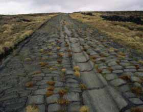
Once there was no military presence requiring communications, did the roads fall into disuse as they very quickly do? The idea that Roman roads survived as built after the Roman period is nonsense. The local peasant economy with a few small towns would not require first class communications. However, modern Roman road excavation argues otherwise. The Bath Archaeological Trust dug a transverse section across the Fosse in 1990 which revealed 13 successive layers of construction, a number of which showed ruts and wear, meaning that they were buried top surfaces. The clear conclusion is that the Fosse had needed to be rebuilt entirely a number of times proving continued and substantial traffic over a long time. This long-term maintenance and successive reconstruction suggests considerable and continuing use. Few documents survive and there are a few glimpses in the wooden tablets recovered from a London excavation. I suggest an analogy with a similar period of history where records are fairly plentiful, i.e. the first half of 18th century England. There are differences: London was bigger than Roman London and the invention of printing made a considerable contribution to commercial information flow. 18th century Britain was the centre of an empire, not the outback province of the Roman world. The similarities are that the population of Roman Britain was 4 million; Britain in 1700 was about 5 million. Apart from London most towns were quite small not too distinct from those of Roman Britain. The 18th century Town population in 1700 was only about 13% and a large proportion of this was in London, and this was probably not too far from the situation in Roman Britain. Good roads arrived for the first time in each. The only motive power for vehicles was animals; canals and steam came later. Roman Britain accommodated gradually to integration in a wider market so, like the early 18th century, Industry was scattered and relatively small scale, though of course later in the 18th century and through the 19th century the industrial revolution gathered pace and utterly outstripped the economy of the Roman world.
Can what is known about early 18th Britain century help to ask questions of and develop interpretations of the Roman Britain economy?
English roads at the start of the 18th century were in a dreadful state. Every parish was responsible for the roads in its boundaries with very little through traffic and virtually no wheeled vehicles in the Middle Ages, this arrangement had sufficed. But in the late 17th century and early 18th century, packhorse trains gave way to wheeled transportation which churned up the roads beyond local capacity for maintenance. As a result, the turnpike system was instituted and tolls were collected at either end of bad stretches of roads and the income was used for repair and maintenance. As traffic increased more stretches were turnpiked and joined to one another until a coherent system of road management and improvement covered the whole country. Likewise Roman Britain was also provided with a coherent constructed system of roads though certainly not all at once. Roads that supported conquest then pacification were presumably the responsibility of the state through its agent the Roman army. The network grew and that once military usage declined in areas that had become peaceful, the roads continued to be used.
Turnpikes inaugurated a revolution in speedy travel and connected the country for the first time since the Roman period. Between 1750 and 1800 the Bath to London travel time decreased from 60 hours to about 10, giving a rough average speed of 2 miles an hour and 10 mph respectively. A Roman example is Emperor Tiberius once managed 182 miles in 24 hours to reach his brother who was seriously ill. For normal travel there are no consistent and systematic data. Pliny in his Natural History estimates up to 1 day was needed for 35 miles in a vehicle, but Suetonius tells us that a raeda , a light carriage , could achieve 100 miles in a day. Professor Ray Lawrence reckons that for freight, oxen could do 2 mph and mules 5 mph, but it is said that in the American midwest a mule could pull a 400 kg wagon 50 miles in a day. Turnpikes enabled much greater weights to be carried. A packhorse could deal with a variety of terrain, but could only carry about a fifth of a ton, whereas one horse with a cart could move one ton provided the road was of good quality.
Roman roads were always capable of carrying loaded vehicles. Towards the end of the Roman period the Theodosian legal code of the late Empire restricted loads to 430 kg perhaps because of the potential damage to roads. Ruts in metalled surfaces and multiple rebuilds bear witness to such damage.
Josiah Wedgewood was a great promoter of turnpikes and relied on independent road and water carriers to move his ceramic products throughout the country. In the Roman world whetstones originating from the Weald in Kent have been found throughout Roman Britain, from southern Scotland to the English channel. A stock of 100 unused blanks were found beneath building rubble in the Roman town of Wroxeter. In our part of the country examples have been found at Ilchester and Uley. These items were small and so easily transported over great distance, although the range is astonishing. Purbeck marble from south Dorset also had a wide distribution. The pottery at La Graufesenque in southern Gaul, with its 600 potteries, not only covered the whole of Roman Britain and into Scotland, but as far as the Sudan and India. The building of the town walls of Silchester alone required tens of thousands of wagon loads upon its Roman roads. Horse drawn traffic on quality constructed roads can contribute to a thriving market economy, even over distance. As the 18th century economy grew and the turnpikes spread all over the country, the arrival of canals in the late 18th century did not dent the rise of road borne traffic. Indeed water borne transport was always a smaller part of the communications system and the evidence suggests this was certainly the case in Roman Britain i.e. that waterborne traffic was not as important.
The North Somerset Roman Road Project has been looking at an area which is clearly not full of high status sites like cities or fortresses, but the map shows a number of significant sites:
Gatcombe west of Long Ashton outside Bristol was formerly thought to be a very odd villa with lots of manufacturing activity and surrounded by massively thick walls. Bob Smisson has argued in an article in Britannia Journal that geophysics indicates a walled area of about 13 ha, comparable with the Roman towns at Caerwent and Ilchester. There are also buildings outside the wall area. This suggests that here is a small walled town of some importance.
At Winthill south of Banwell it has been proposed that this is a small town with lead mining and metalsworking.
Charterhouse-on-Mendip was a lead mining town covering 25 to 30 ha and protected by a small fortlet.
The Saint Georges settlement east of Weston-super-Mare was involved in major salt production “on an industrial scale …….. and not just for local consumption”, according to Neil Holbrook, the excavator.
At Congresbury pottery production and iron working was established, but no settlement has been found.
At Dundry Roman stone quarries existed west of the village and its stone has been found at Caerleon in south Wales.
There are villas at Banwell, Wemberham and possibly at Star, Locking, Gordano, Lye Hole, near Towerhouse Wood and various settlements at Scar Hill, Row of Ashes farmstead.
Communications were needed between these communities and commercial activities, if not of the standards of the long-distance state roads, the viae publicae , then at least of sufficient load-bearing capacity for such as stone and lead and bulk agricultural produce. Professor Ray Laurence tells us in his book on Roman roads that local roads classified legally as viae vicinales were built and maintained by local communities, go off across the countryside for local use and often tie in with the state viae publicae. The Roman legal surveyor Siculus Flaccus states that they were open for public use and were maintained by the local city council. Charters survive setting out the Constitution of cities as the Lex Tarentina for a town in southern Italy.
In the Imperial heartlands there had long been a tradition, even an expectation, not just in Rome but in every community, that the elite families should benefit their local home localities with festivals, public buildings, infrastructure. Local aristocrats were given the power to run their areas and even levy taxes which could be very profitable, but in return they must take local responsibility for providing activities as above. Based on the chief city of an area, a Council titled an Ordo comprised a set number of members known as Decurions and was headed by regularly elected magistrates i.e. executive officers. As with modern systems of local government, the state had oversight and could be involved in major decisions or problems. Can we detect a local network of minor roads, viae vicinales decreed by the local Ordo, in Roman Britain? A group of us have been attempting to do just this in North Somerset.
Here are some of the possible roads we have been investigating:
Banwell/Winthill to Saint Georges (east of Weston super Mare ). Winthill is described in the North Somerset HER as “a small Roman lead mining settlement“, but a local archaeologist reckons the area is quite large. There is a good scatter of find spots here and in Banwell just to the north. Saint Georges Roman saltworks and settlement are a significant site and a road between the two industrial areas seems likely. The line might be the straight length of Woolvershill Road, continued on the far side of the M5 by a bridlepath with a ditch on one side and a rhyne on the other and then by a straight tarmac path among houses as far as the A370, and perhaps beyond, all in the direction of the Saint Georges Roman site. We hope for an excavation of the bridlepath.
There has long been discussion about a road proceeding west from Charterhouse continuing the line of the known road from the south-east (which goes to old Sarum and Winchester). No certain accepted line has been found, but with the identification of Winthill as a small Town, a connection with the significant town site at Charterhouse seems to me very likely. We have postulated a possible route but geophysics on one part has shown only possible traces, with the field having been deep ploughed in the past and the bedrock is not far below the surface. It is hard to deny a connection of some sort but we may or may not be on the line yet.
The Iwood Road. A long line of straight hedgerows with one characteristically shallow angled bend proceeds probably from Winthill /Banwell going north east, following Iwood Lane and climbing into Broadfield Down, perhaps to meet an East West route from Congresbury to Gatcombe . This latter is still under investigation.
The Nempnett Road. A long line of straight hedgerows passing close to the east of Nempnett church. Projecting north it might proceed to Gatcombe or to Dundry and meeting up with the proposed road through Bishopsworth in south Bristol and passing near to the Roman quarries. To the east of its line and northwest of Chew Stoke, is the Roman temple complex on Pagan’s Hill, to which one would expect a connection.
Such roads would not be the major state highways, the strategic routes, but would serve local economic and community needs, criss-crossing a thriving small but vibrant part of the Roman world. I suggest they were promoted, just as was the case with turnpikes by local land owners and commercial interests and had nothing to do with the Roman army despite the frequent straightness. They would nicely fill that strange empty space between the known main roads that that currently appear on our maps, encircling the area of North Somerset and seeming, wrongly in my estimation, to suggest this area to be without roads and devoid of significant activity during the Roman period.