
Straightness of Roman roads is their defining characteristic and has spawned many ideas about how it was achieved. The question posed was, how to ensure directness overall for the whole route of the road. For example starting from the Devon/Dorset border, how did Roman engineers know in which direction to point the Fosse Way to arrive at Lincoln, nearly 200 miles away. Hugh Davies (Roads in Roman Britain) suggests that route surveys included large scale mapping, although no evidence exists. Some suggestive scraps of evidence survive, such as Frontinus ( `de Aquis urbis Romae`, written as Curator of Rome’s aqueducts, before later becoming Governor of Britannia) states, “I also took care to make maps… I could discuss the situation as if I was on the spot”. Fragments of a huge map of the city of Rome at a scale of 240:1 survives and fragments of a public stone land registry from Orange in France (Roman Arausio) showing roads and a river whose representation can fit a modern map.
The first recorded Roman road was started, according to Livy’s History of Rome, in 312 BC. By the time of Claudius’ invasion of Britain in AD43, a dense network of well-engineered, all-weather roads covered Italy and the more Romanised areas of the Empire. Fine stone bridges abounded. Gradients were eased by cuttings, viaducts, embankments and terraces. Tunnels bored through rock obstacles. The Romans invading Britannia had nearly four centuries of road building experience behind them.
Roman Roads in Avon
A Roman road starting from the lead mines at Charterhouse, led to Roman Winchester and on to a port at Bitterne (now inSouthampton). Lead pigs from Charterhouse have been found along this route including the port; further examples have been found in France and a utensil found at Pompeii. Pigs are often inscribed; the earliest found is dated to AD49 showing the mines working only six years after the invasion.
The first stretch of the road simply shows dots on the Ordnance Survey map indicating the presumed line, since there is no surface evidence from continuous hedgerows, modern roads or tracks, or a visible agger (Latin for embankment/rampart). The line has now been revealed by LIDAR (Light Detection and Ranging), a kind of radar scan from the air that can remove vegetation from images, but clearly shows the shape of the landscape and its anomalies . This new tool, available free from the Government website, has revolutionised finding new Roman roads and disproving some assumed ones.
Near the Miners` Arms on Mendip, the agger is visible. When excavated by McMurtrie in 1906, a simple construction emerged – cambered top surface; about 7 inches depth of red sandstone pebbles mixed with fine stone and earth; next, 4 to 7 inches of black earth or clay; at the bottom, yellow clay natural.
The Fosse Way Roman road crosses Avon. Its directness from the Devon/Dorset border via Bath, Cirencester, Leicester to Lincoln is remarkable; if a straight line is ruled on a map between the endpoints, then at no point does the road deviate more than 6 miles from that line. It covers a distance of over about 200 miles. It looks purposeful and many regard it as an early frontier of the new province. A road like this could take several years to build, would eat up resources and would soon be redundant as Roman military activity is evident around Wroxeter by AD47 only four years after the invasion. A large portion of the Fosse way passes the Dobunni tribe who seem no threat.
Neil Holbrook (Cotswold Archaeology ) says military sites are not being found here and that the Dobunni were not intensively garrisoned. Hugh Davies suggests it was a link between IX Hispana Legion in Lincoln and the II Augusta Legion in Exeter on the two flanks of the Roman advance. When II advanced to Caerleon in South Wales and IX to York, its importance declined. Perhaps it was only conceived as temporary; overall average depth of metalling is less than the average of all Roman Britain roads and at 5.3m wide, it is the narrowest of all major roads (half the average of Watling Street).
South of Bath, a modern A road follows the Fosse line, suggesting continuous use since Roman times. In places, the modern road deviates briefly from the Fosse and at Clandown in the 1990s the Bath Archaeological Trust excavated a section, finding a complex vertical sequence of no less than 13 layers. Wheel ruts and traffic-worn surfaces were identified at different levels and were interpreted as successive repairs and reconstructions over the life of the road, indicating heavy use over a protracted period. The traffic-bearing top surfaces comprised well laid, very hard packed gravel.
Another probably early road is one that connected Bath with Sea Mills and the Roman town of Abonae near Bristol. After the Bath suburb of Weston, it climbs steeply up to Prospect Stile (near Kelston Round Hill). Steepness suggests it might have been an early military road. Extra draught animals perhaps were used, kept at a mansio or way station (just as extra animals were used for coaches on steep turnpike roads).
From Prospect Stile to North Stoke, a terrace in the side of the hill carries the road. Trice-Martin excavated about 100 years ago and found metalling of small stones, 2 inches diameter, with a depth of 8 inches, rammed in and set close together.
Once the road passes through Bitton on the line of the A431 and into Hanham, its route through Bristol is lost until it emerges on the Downs near the Water Tower at the junction of Ladies Mile and Stoke Road. It then proceeds visibly across the Down to the junction of Downleaze and Saville Road. Trice-Martin also excavated here and found a continuous layer of stones bedded in with 6 inches deep of reddish earth, above 12 inches of sandy earth. A recent dig in a garden on Stoke Park South Road near the Downs revealed ` a layer of variously sized and closely laid stones 10 to 15 cms deep above reddish-brown clay…… the rounded and worn nature of the stones suggests sustained use of a well-used road`.
Several other examples from Avon were briefly mentioned, such as the road from Sea Mills to Gloucester.
The roads described above and many other excavated examples in Britain show no set pattern, with varying widths and amounts and types of metalling and other variables, including in the same road over time; complex layers reflect periodic reconstructions rather than a fixed layer scheme; top paving is virtually non-existent in Britain, mostly gravel or pebbles (even Italy`s famous Via Appia was not paved for its first five hundred years ).
The military were not the main users of Roman roads in the south after initial period of conquest. Within thirty to forty years, all forts were decommissioned as the military moved north. Yet the much reconstructed Fosse at Clandown and other examples show prolonged use. Cato and other Roman writers describe roads as valuable assets for agricultural traffic. Many Roman vehicle representations show a variety of passenger and freight uses. Road transport, once considered too slow and expensive to be worthwhile, responds to demand and profitability, rather than cost only – as argued by Professor Ray Laurence of Kent University. Even now, the relative cheapness of bulk sea freight does not obviate the increase of roads and vehicles. In the burgeoning 18th century Britain, with horse drawn vehicles on (Roman style) turn pike roads, the costliness of road transport compared to water did not prevent expansion. I suggest that Roman roads outside military areas were a scene of vibrant traffic.
By the 5th century, the economy of Roman Britain had collapsed. Money went out of use. Civil administration ceased and roads were no longer maintained and quickly became dirt tracks, remaining in this sorry state for one and a half millennia until the turnpike revolution from the likes of Thomas Telford and MacAdam came into being.
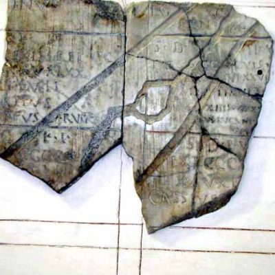
Roman roads Cadaster of Orange (1)
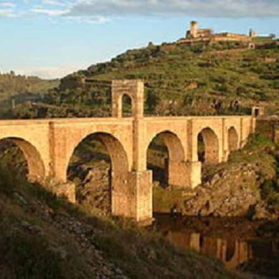
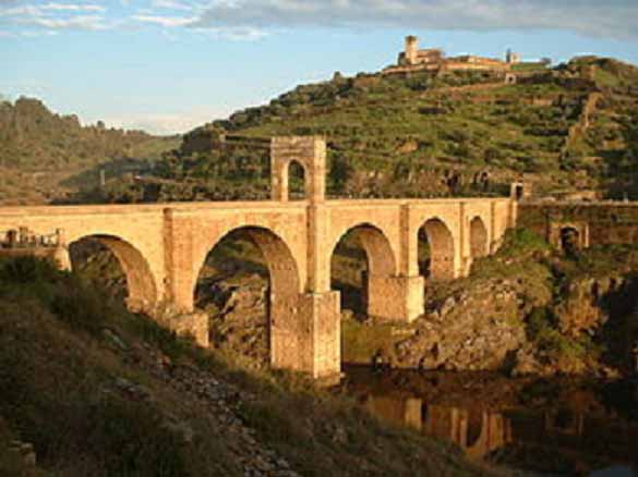
Roman Bridge