
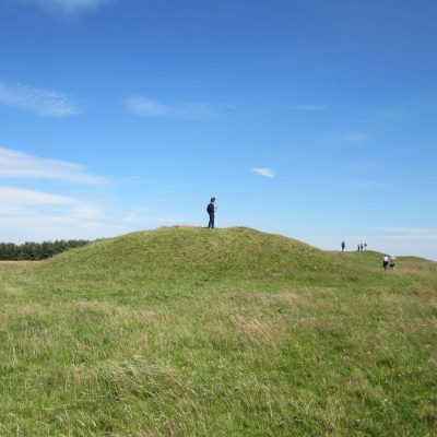
Jodie’s research is on the Mendip plateau and she is currently working in Priddy. This is an upland limestone plateau which runs from Uphill to Frome. North Hill is home to the Priddy Nine Barrows and those on Ashen Hill. They are situated at 300m OD. This is the only hill that rises from the plateau of Old Red Sandstone (Portishead Formation). The soils are acidic. There are far reaching views from North Hill and the barrows date from 1800BC. There are earthworks and enclosures and the Priddy mineries (lead works) which are now scheduled. A lot of quarrying took place in the Post Medieval period.
Jodie’s fieldwork took place in 2012-15 with excavation on the lower slopes of North Hill; 2013 on a mound 20m south of the Priddy Nine Barrows; 2015 geophysical survey of the banks and ditches. In 2012 fieldwork at Eastwater Drove on 2 round mounds, possibly Bronze Age barrows. In 1816 Rev. John Skinner had investigated them. One had a cremation and an arrowhead; the smaller barrow had no finds – is it a barrow? Geophysical survey produced nothing. A quadrant was excavated and the excavators came down on to stones in a curved ring 14m in diameter. Inside the ring of stones were turves stacked against the natural rocky ground. There was cremated bone ib tge gughest oart dated 1780 – 1660 cal.BC. A thousand flints were recovered including scrapers. There was an old excavation pit 30 cm deep (was this Skinner’s?), a penny cartwheel dated to George III. The question is, is this a round barrow as it is not typical, but it is a funerary structure. It is unique to Mendip. Comparisons can be made with sites in Cornwall and Wales.
2013 at the Priddy Nine Barrows, mound 5 was investigated. It is less than 10m in diameter. Geophysical survey was not conclusive. This was a small round barrow.
A ring cairn 9m in diameter consisted of stone and earth. At the centre was a rectangular pit covered by a cairn. It had been previously opened. Inside were some cremated bone fragments dated to 1880-1690 cal.BC but no grave goods.
A further mound, 9m x 40cm had a cut of a narrow circular slot. Flints were recovered together with a lot of white stone (lias) placed around the edge of the mound.
At North Hill, 30m from the Priddy Nine Barrows is another Bronze Age barrow. ¼ – 1/3 of the barrows have been previously opened, possibly including this one.
An earthwork enclosure south of the Priddy Nine Barrows is noted on the HER as “earthwork stock enclosure, Medieval/Post Medieval”. This monument has an irregular shape. In 2014 geophysical survey was undertaken on the inner and outer ditches and trenches laid over bank and ditches. It proved to be a multi-phased monument that was adapted and used over a long period. It had a primary bank and a secondary bank, which was stony. There was an inner rock cut ditch; an inner ditch and an outer bank but no finds. The outer ditch is ‘V’ shaped which was re-cut. Roman glass 1st – 2nd Centuries AD and pottery was recovered. The earlier site was re-modelled and the outer ditch had an odd collection of stones that were placed around a cut in the ditch fill. It was not a grave but, was quartite rich and this stone is not natural to the site. There was a zoomorphic shape. The site was interpreted as Neolithic/Bronze Age, but the Romans had modified it, but why this was done is uncertain – possibly as a shrine? It overlooks the Priddy Roman Villa and St. Cuthberts Roman lead mining. It has identical white stones dotted around it, like the barrow.
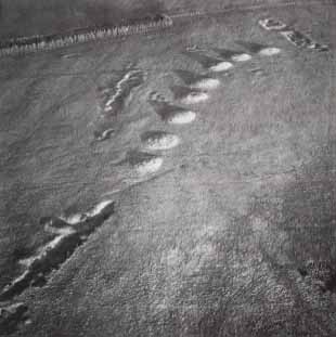
In 2015 at the Priddy Nine Barrows excavation and survey was carried out around the barrows themselves. There is 120m between barrows 1-7 and 8 and 9. Geophysical survey showed nothing. Further geophysics was carried out around the 7 main barrows and one was a ring cairn.
Mendip is a place where different traditions come together in the Early Bronze Age. A great deal of geophysical survey has been carried out especially in the gap between the barrows. Curving east west is a bank between the barrows 365m long and up to 1m high. The HER says it is a Post Medieval boundary. It stars at a spring and curves over the hill and it is segmented. Two trenches revealed a bank and ditch with the ditch being re-cut. It was 2.4m side and 0.8m deep. It is dated to 3600 – 3500 cal.BC. It is the earliest Neolithic monument on Mendip. It may be related to the causewayed enclosures where there is space for gatherings and rituals, but it is not a typical causewayed enclosure. Pollen analysis shows it was built on a grassland environment.
Overall interpretation: two new Bronze Age round barrows have been discovered. There is diverse architecture on Mendip and small barrows are not necessarily earlier or later. Surface observations are not sufficient to understand the monuments. Not all enclosures are stock enclosures; the Romans re-used earlier sites. At North Hill Roman activity needs to be better understood as it is not all related to Charterhouse. Future research needs to look at more earthworks to be interesting.
Ashen Hill round barrows Priddy Nine Barrows (Aston & Burrow 1982)