
Paul began with two general observations: firstly, that many archaeological investigations have a long gestation from the first assessment of the site until the final report, and this process can take years; secondly, that archaeological work is done most often on sites being developed and so are much denser in built-up areas. (For a fuller explanation of how this all works, see the end of this article). Paul explained that he would cover a number of sites explored over recent years starting with investigations on prehistoric sites. These do not figure a great deal In archaeological investigations. There are, of course, many examples in South Gloucestershire, but these are either well-known or not yet investigated.
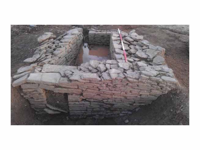
Uncertain water structure at Emerson’s Green
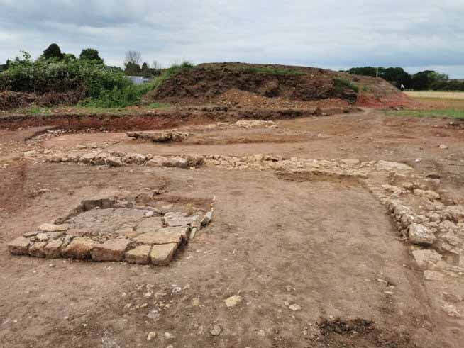
Medieval building at Wyck Beck Road
The first of three examples is located near Willow Farm, Hallen, where boreholes revealed palaeoenvironmental data over the Meso-and Neo-lithic periods. The cores extracted from the borehole drills give an eco-history and a record of land usage and change on the clay and silt mudflats from 5300 to 3800 BC. For example hazel, oak, and elm flourished earlier, but by about 3800 BC, elm disappeared from the record. Radiocarbon dating provided accurate timings. Periods of flooding were evident, especially as the River Severn continued to rise.
Peg Hill, Yate. This is a bit of a mystery. Geophysics led to the discovery of a Bronze Age burnt mound. This comprises layers of burned and shattered stone and also remains of clay-lined wooden troughs. No clear purpose has been understood for these mounds. (Wikipedia has an interesting discussion). Its date ranges from 1500-1300BC.
Oldbury camp, Oldbury on Severn, has a double ringed rampart, but far from being the well-known type of la hill fort it is a low-lying marshland fort. Not a lot of finds have been recovered but they can be dated from the 3rd to the second century BC, using the dating method OSL. The letters stand for “optically stimulated luminescence“. The ramparts were built in the first century BC, which is late Iron Age.
Most sites investigated turned out to be from the Roman period, although some showed continuation from the late Iron age. Many lay near to the river Severn on land reclaimed during Roman times. This reclamation, comprised long lengths of sizeable earth walls, plus drainage systems, requiring huge efforts, not just to build but to maintain them. This system was basically lost post Roman. No villas existed in this area. The farmsteads are simple structures, usually enclosed by ditches, simpler than complex farmsteads, which have a sizable range of features and findings. These investigations show a spread of agricultural activity, whose extent was not so well known before the developer planning legislation of 1990.
Plot 4000: Investigations revealed a settlement with roundhouses and sub rectangular structures which lasted from the second century A.D. to the fourth century, together with an accompanying field system.
Matrix 49. (Tesco warehouse). Excavations contained deep ditches and a likely roundhouse, probably adding up to a farmstead. Finds included some Samian type pottery and a military buckle.
The site at Washington Farm had three phases. The first provided many objects and finds dated to the late Iron Age. Later phases included a droveway (implying animal management) and a possible corn dryer (indicating arable farming as well). Pottery imported from southern Gaul was evident suggesting a degree of prosperity. The main period lasted from 2nd century to the 4th century A.D., but thereafter there was clearly insufficient labour and investment to maintain the sea banks which protected the reclaimed land.
Park Farm site, near Thornbury, displayed substantial land division ditches, 2 to 8 m wide and pretty deep – obviously some kind of statement here! No settlement was discovered, but was probably nearby and could well be an enclosed farmstead. Activity continued from the first century A.D. until the second century, when the site was abandoned.
The Post Farm site, near Thornbury, revealed yet another enclosed farmstead, with huge amounts of pottery. 13 burials included one with the head removed and placed between the legs, a strange, but not uncommon practice.
Brimsham, near Chipping Sodbury, gave us another enclosed farmstead, not a villa but containing high status materials, such as Samian ware, and other ceramics, together metal objects. Its dates stretched from the first century to the early fourth century A.D.
Wyck Beck Road, North Bristol. Finally, the last enclosed farmstead, with Romano British finds. In mediaeval times a high status hall was built here. A kiln was found, which may have been connected with malting.
Emersons Green villa was situated well away from reclaimed land to the north east of Bristol. It emerged in stages. In the first century A.D., there were some enclosures, and in the second century, these were enlarged. Finally, in the late third century, a new high status Villa was built, with dyeing production.
This small sample illustrates how workaday farmsteads constituted the majority of Romano British dwellings to be found in the countryside. In the past, when there was not a multitude of archaeological investigations and only villas attracted a great deal of attention (largely because of their cultural and artistic features), there was a temptation to think that they were the main institutions to be seen in the countryside. Now, it is clear that villas form only a very small proportion of the rural habitation.
There follows a discussion of how most archaeological work is done these days. They mostly result from planning Applications for housing or a road alteration or some such. The developer has to provide and pay for an archaeological assessment for the area affected by the development. They start with a desktop assessment to see whether previous Records show the likelihood of archaeological features on the area of interest or nearby. The developer has to provide and pay for an archaeological assessment for the area affected by the development. This is then examined by the County Archaeologist who may require as a condition of planning consent that the site should be fully investigated. If significant archaeological potential is discovered by geophysics or trial trenching, then, as a further condition, large-scale excavation may be required, to be organised at the developer’s cost, and carried out by an approved commercial archaeology firm. Occasionally, if important archaeological remains are discovered, then they are preserved. Usually the site is fully and carefully recorded and important finds are lodged with the nearest museum, or exceptionally, if of major significance within an important institution, such as the British museum in London. Since the process began in 1990, vast amounts of data have accumulated: museum basements are bursting with stored finds, and what is actually on public display forms only a small proportion. Important records are published online, or in booklets, or in journals, such as our own Bristol & Avon Archaeology; the great mass of records remain with the archaeology commercial companies, that can be accessed by the public on request. No longer, as in the past, do occasional discoveries prompt questions of how typical they are; now large-scale analysis and statistical examination of whole types of structures, settlements, and so forth can be made on a nationwide basis. A good example is the three volume data-backed “Rural Settlement of Roman Britain”.